Introduction
Mt. Kailash, 6,740 m. is situated to the north of the Himalayan barrier, wholly within Tibet. It is the perfect mountain in so many ways and stands serene with its awesome beauty / four great faces look out to this world and the one beyond. It is the spiritual centre for four great religions: Tibetan Buddhism, Hinduism, the Jain religion and the pre-Buddhist animistic religion – Bonpo.
To Tibetans it is known as Khang Rimpoche (Precious Jewel of Snow) and they see it as the navel of the world. It is said that a stream from the mountain pours into a nearby lake and from here rivers flow in the four cardinal directions. The River of the Lion Mouth to the North, the River of the Horse Mouth to the east, the River of the Peacock Mouth to the south and the River of the Elephant Mouth to the west. Strangely enough coincidence maybe or just perhaps a little more mysterious than that?. Four major rivers do indeed originate near Kailash, the Indus, the Yarlung Tsangpo (Brahmaputra), the Karnali and the Sutlej. Tibetans believe that it is the residence of Demchog, a fierce looking tantric deity who lives there with his consort, Dorje Phagmo. For the Tibetans also it is a particularly special place where the poet saint Milarepa, spent several years here meditating in a cave.
For the Hindus Mount Kailash is the earthly manifestation of Mt. Meru, their spritual centre of the universe, described as a fanatastic ‘world pillar’ 84,000 miles high and around which all else revolves.Its roots are firmly rooted in the lowest hell and its summit rises so high to kiss the heavens. On the top their most revered God, Shiva, and his consort Parvati live.
For the Jains, an Indian religious group, Kailash is the site where their first prophet achieved enlightenment. For the older, more ancient religion of Bon, it is the site where its founder Shanrab is said to have descended from heaven. It was formerly the spiritual centre of Zhang Zung, the ancient Bon Empire that once included all of western Tibet. Bon people walk around the mountain in a counter clockwise manner, unlike the other religions.
Over the centuries pilgrims have constantly journeyed immense distances to achieve enlightement or cleanse themselves of sin, braving enourmous distances, particularly harsh weather and bandit attacks.
Although the main focus of this trek is Mount Kailash in Tibet, the journey through Nepal’s border with Tibet at Zhangmu, Saga and Paryang to Darchen is culturally and scenically rewarding.
The Simikot Kailash trekking trail is one of the most popular trekking routes in Tibet, however compared to Nepal there are very few people on this trail .The trek offers superb Himalayan scenery and beautiful landscapes, all so neatly blended in with the warm hospitality and traditional culture of some wonderful high desert like people.The trek commences in the Humla region of Nepal, near to the Tibetan border with the trekking part of this tour finishing at Holy Lake Manasarovar and then completing a chora around the sacred mountain Mt Kailash. You travel through some magnificent mountain scenary, past old villages along rivers and across the Nara Lagna Pass. From the high pass at 4585mtrs the vast Tibetan plateau spreads out like a giant golden blanket in the distance.
The journey to the Nepal Tibet border takes five days, the border only being marked with a stone.The first village we reach is Sher on the Tibetan side where a vehicle is waiting to drive the group to Taklakot. Geographically Taklakot is directly south of Holy Mount Kailash. On the way to the holy mountain we walk the western shore of Lake Mansarovar and make camp.There are many beautiful landscapes in the Himalayas but there are few that can match the view from Gosul Gompa across the lake and the surrounding mountains. Take time to relax and soak it all in as it wont be there for you in the same way tomorrow. The following day together with many other pilgrims commence the trek around Kailash, the trail across the Dolma La (5600m) is thronged with countless prayer flags. The trek itself takes three days to circumambulate the snow-covered Kailash 6714m. In true Tibetan tradition the pilgrimage finishes at Tirthapuri – one of the most important pilgrim destinations along with Kailash and Lake Manosarovar.
Inclusion
What's included ?
What's not included ?
Day to Day Itinerary
-
Day 01: Arrival Kathmandu transfer
To hotel, Tibet Lhasa tour briefing with official arrangements.Overnight in Kathmandu. -
Day 02: Sightseeing and Preparation day
After breakfast passports are taken for a visa at Chinese Embassy Kathmandu.You spend the day with our guide sightseeing around The Kathmandu Valley including Pasupatinath, Boudhhanath, Kathmandu Dubar square , Sywambhunath ( Monkey temple) return to hotel. Late afternoon to prepare for the Tibet tour. Overnight at Kathmandu. -
Day 03: Fly to Nepalgunj
We take the ninety minute flight to Nepalgunj in the far south west of Nepal a bustling and crowded city which lies close to the Indian border. -
Day 04: Fly to Simikot [2960m], trek to Dhara Pokhari [2300m]
Early flight north for about 50 minutes to Simikot, the headquarters of Nepal’s most remote district, Humla. Here we pick up the trekking crew and set off on our trek.To begin with there is a climb up from the airstrip on a rocky trail past fields of barley and wheat. We need to ascend a forested ridge above the town of Simikot before making a steep descent past Dandaphoya. The trail is then levels off somewhat travelling through walnut and apricot trees until we come to Dharapokhari which is divided by the Yakba Khola. -
Day 05: Trek to Salli Khola [2700m]
Leaving our campsite fairly early we first need to cross a long scree slope and follow the river to a waterfall near the shepherds’ camp at Chachera. There is then a climb over a ridge that makes a bypass of the village of Kermi.Soon we enter a large valley with walled fields of potato and buckwheat. After walking through a sparse pine forest we descend from the ridge to the Salli Khola and camp by the river. -
Day 06: Trek to Muchu [2920m]
We cross the river and climb over a rocky ridge before descending to the grey waters of the Humla Karnali. After crossing another ridge we come to a sandy meadow where goat herders often camp by the river. Beyond the meadow the valley narrows and we cross several more ridges, passing the villages of Yalbang and Yangar. The trail then winds its way precariously above the river before we cross a suspension bridge to the village of Muchu. -
Day 07: Rest day
Today is a rest day which we’ll spend in and around Muchu, exploring the village with its stone houses and gompa. rom Muchu, we follow the trail over a ridge to the Tumkot Khola and then walk along the rocky stream bed for a short distance before beginning a steep climb through a rock-filled gully. We pass through Palbang and its bright yellow mustard fields to the small settlement of Yari and beyond here the route climbs up the valley towards a pass, the Nara Lagna. We camp below the pass in a meadow known as Sipsip. -
Day 08: Trek to Hilsa [3720m]
From Sipsip we ascend steeply to a rock cairn marking the top of the Nara Lagna [4580m]. Descending from the pass, we have views of the Tibetan Plateau before arriving at the village of Ranipauwa. Beyond here, we slip and slide on a surface of loose pebbles down to the Humla Karnali. -
Day 09: Trek to Taklakot [3930m], drive to Manasarovar [4560m]
Shortly after crossing the Nepal/Tibet border which is marked only by a stone pillar, we meet our transport and drive about 130km, via the large trading centre of Taklakot, to Manasarovar, the most venerated of Tibet’s many lakes. -
Day 10: at Manasarovar
Today will be spent at Manasarovar, allowing our bodies time to acclimatise to the altitude and exploring this fascinating place. We will visit the picturesque Chiu Monastery on the north west shore of the lake with the imposing sight of Mt Kailash in the background. -
Day 11: Drive to Tarboche [4750m]
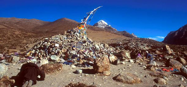
Leaving the lake, we drive for about 35 km towards Mt Kailash and Tarboche which is marked by a tall pole adorned with prayer flags. This is the starting point for our kora, the 53km trek around the mountain. -
Day 12: Trek to Dira-puk
From Tarboche, we walk up the Lha Chu Valley through beautiful green meadows and streams with Mt Kailash towering above us. We follow the river which enters a narrow canyon with high, steep cliffs and spectacular waterfalls. Continuing up the valley, the north face of Kailash comes into view before we reach the 13th century monastery at Dira-puk. -
Day 13: Trek to Zutul-puk [4790m]
Today we leave the Lha Chu Valley and enter the Drolma Chu Valley, heading up towards a high pass, the Drolma La [5630m]. It’s a strenuous climb to the summit which is covered with prayer flags from the pass it is all downhill to Zutul-puk with some wonderful views of one of the highest lakes in the world, Thukpe Dzingbu Lake known as the Lake of Compassion. There is a monastery at Zutul-puk to explore along with several meditation caves and another cave containing an image of Milarepa. -
Day 14: Trek to Darchen [4560m]
On the final day of the Kora we cross several streams, and follow an impressive gorge. Along the way we are once again treated to magnificent views of Kailash. We then enter the Bharka plain and it’s about an hour’s walk through this desert-like landscape to Darchen. -
Day 15: Drive to Paryang [4750m]
Today is a long drive about 300km to Paryang. Along the way we cross the Mayun-la and make several river crossings. The scenery along this section is some of the most panoramic of the entire journey. -
Day 16: drive to Saga [4600m]
We continue driving today along a 255km stretch of road to Saga, passing through the small, dusty town of Zhongba en route. -
Day 17: Drive to Peiko-Tso
Leaving Saga, we cross the Yarlung Tsangpo [Brahmaputra River] by ferry and continue our journey for 110km across the vast open plains. Stunning Himalayan views particularly of Shishapangma as we head towards a huge lake, the Peiku-Tso. -
Day 18: Drive to Zhangmu [2300m]
Today we drive 180km south towards the Nepalese border joining the Friendship Highway. We cross a high pass, the Lalung La [5200m], and come to the small town of Nyalam. From here the road drops steeply down through a mossy gorge with cascading waterfalls before reaching the border town of Zhangmu. -
Day 19: Drive to Kathmandu [1400m]
From Zhangmu, we drive down a very steep section of switchbacks to the Friendship Bridge which spans the Bhote Kosi River and marks the Chinese – Nepalese border. We say goodbye to our Tibetan guide and driver and walk to Nepalese Immigration Control in Kodari where we are met by our Nepalese staff. After completing the re-entry formalities we continue the 123km drive to Kathmandu which, depending on road and weather conditions, should take about 5 hours. -
Day 20: After breakfast departure for onward destination